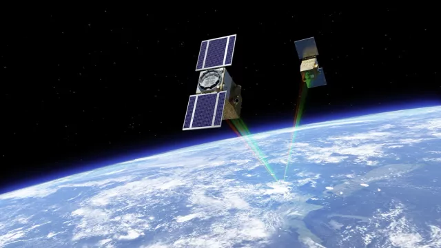
A joint mission of the French (CNES) and Israeli (ISA) space agencies, C3IEL—for Cluster for Cloud Evolution, ClimatE and Lightning—is dedicated to studying convective clouds from space. A scientific and technological world first, the mission consists of a train of two nanosatellites synchronized to observe the same cloud scene from different angles. Its aim is to measure:
- cloud development at the top of convective clouds at high resolution
- surrounding water vapour
- electrical activity inside these clouds
Key information
| Mission | Observe the dynamics of convective clouds |
|---|---|
| Domain | Earth observation |
| Launch date | Planned late early 2028 |
| Partners | Israel Space Agency (ISA), French research laboratories: LOA, LAERO, CNRM |
| Where | Sun-synchronous Earth orbit between 600 and 700 km |
| Lifetime | 2 to 3 years |
| Status | In development |
Key figures
- 11 stereoscopic acquisitions of clouds every 20 seconds
- 45 kg mass of each nanosatellite
- 200 seconds’ scan time when acquiring diurnal cloud scenes
- 20 minutes’ scan time when acquiring noctilucent cloud scenes
Key milestones
- Early 2028: Launch of two nanosatellites
- 2024 to 2027: Phase C/D of development
- 2024: Phase B1 of development
- 2023: Phase B0 of development
- 2021 to 2023: Mission on standby
- 2020 to 2021: Phase A of development
- 2017 to 2020: Pre-phase A of development
- 2016 to 2017: Phase 0 of development
- 2016: CNES and ISA initiate the C3IEL programme to study convective clouds at high spatial and temporal resolution
Project in brief
Clouds are key elements of Earth’s climate system, so developing a deeper understanding of their dynamics would improve weather and climate prediction models. The French and Israeli space agencies have decided to study convective clouds—also called cumulonimbus—because they can trigger intense and sometimes destructive storms. The processes at play during such episodes are still poorly understood. Thanks to the high resolution of the C3IEL mission’s instruments, it will be possible to precisely delineate such clouds—something that until now has proved elusive due to their vaporous texture.
The mission aims in particular to:
- Quantify development of convective clouds at high spatial resolution
- Study their relationship with water vapour at different levels in the atmosphere
- Study how their dynamic and microphysical properties affect their electrical activity
C3IEL will also seek to record the distribution and size of convective clouds and cloud structures spanning a few hundred metres.
The mission consists of identical twin nanosatellites carrying CLOUD visible-spectrum cameras to track cloud envelope dynamics with images at a resolution of about 20 metres. They will also have near-infrared Water Vapour (WV) imagers with a spatial resolution of 100 metres and Lightning Optical Imagers and Photometers (LOIP) to sense cloud electrical activity.
Cloud development will be recorded by multi-temporal stereoscopy, acquiring 11 acquisitions of a same cloud scene every 20 seconds over a scan time of 200 seconds from several viewing angles. These acquisitions will enable spatial rendering of clouds in 3D and measurement of their rate of growth. This viewing and rendering strategy is the chief innovation of the mission.
CNES’s role
CNES is in charge of:
- The space segment, excluding payloads (bus, satellite integration and validation)
- The command-control centre and associated resources
- Mission planning resources
- Satellite operations
- Part of the mission ground segment, notably processing of geometric corrections
CNES contacts
Project Leader
Laurène Gillot
E-mail: laurene.gillot at cnes.fr
Atmospheric Physics & Meteorology subject matter expert
Adrien Deschamps
E-mail: adrien.deschamps at cnes.fr


