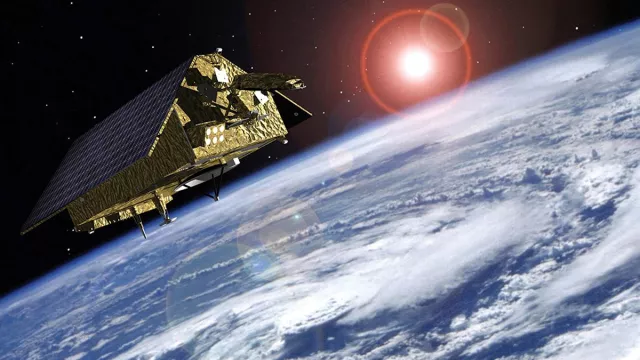
Since 1992, satellites have been precisely measuring ocean surface height from their orbital perch 1,336 kilometres above Earth. To extend the time-series of data crucial to our understanding of the mechanisms driving global warming, a new satellite was launched in 2020 and will be followed by another 2026.
Key information
| Mission | Precisely measuring ocean surface height |
|---|---|
| Domain | Earth observation |
| Launch date | First satellite launched 21 November 2020 |
| Partners | European Union, ESA, Eumetsat and NASA with support from CNES, NOAA (USA) and Airbus Defence & Space |
| Where | Highly inclined circular orbit (66°) at an altitude of 1,336 km |
| Lifetime | 5½ years plus 2-year extension |
| Status | In development |
Key figures
- 2 Sentinel-6 satellites
- 10-day revisit interval to same point
- 1,420 kg: mass of each Sentinel-6 satellite
- 6 instruments and units on each Sentinel-6 satellite
Key milestones
- 2025: Launch of Sentinel-6 B
- 21 November 2020: Sentinel-6A/Michael Freilich launched by Falcon 9
- 1 December 2015: ESA/Eumetsat agreement approved by Eumetsat
- 9 September 2015: Eumetsat joins project
- 11 May 2015: ESA awards contract to build Sentinel-6A to Airbus Defence & Space
- 2014: Copernicus programme enters operational phase
- End 2013: ESA gives go-ahead to Jason-CS/Sentinel-6 programme
- 2012: GMES initiative renamed Copernicus
- 2001: EU and ESA launch Global Monitoring for Environment and Security initiative (GMES)
- 1998: Baveno Manifesto proposing an operational Earth-observation programme
Project in brief
In 1992, TOPEX/Poseidon was the first ocean-observing satellite to be placed in a highly inclined orbit at an altitude of 1,336 kilometres, covering 95% of the globe’s ice-free oceans every 10 days. In 2001, Jason-1 and then in 2008 Jason-2 were positioned in the same orbit, later joined by Jason-3 in 2016.
Together, these French-U.S. satellites began accumulating an exceptional data record on ocean topography, enabling scientists to track the peaks and troughs generated by ocean currents and to precisely determine sea level rise. To pursue this crucial mission in the context of a warming climate, the Sentinel-6A/Michael Freilich satellite was launched on 21 November 2020 and will be followed by Sentinel-6B in 2025. They will be placed in the same orbit as their predecessors and carry the same instruments to assure the data consistency so vital to scientific study.
The Sentinel-6 mission is part of the European Copernicus programme and the MyOcean operational oceanography project funded by the European Commission. This mission is being pursued in partnership by ESA, the European Commission and Eumetsat. The United States is also a key partner, with NASA and NOAA playing a role in the launch, U.S. operations and provision of a radiometer, a GNSS-RO receiver and a Laser Retroreflector Array.
CNES’s role
CNES is another key mission partner with the task of precisely determining the satellite’s orbit with the DORIS instrument and 60 associated ground stations, and supplying the GNSS-POD receiver. It is also in charge of assessing the mission’s performance.
Contacts
Development Project Leader
Gilles Tavernier
E-mail: gilles.tavernier at cnes.fr
Copernicus Programme Manager
Hervé Jeanjean
E-mail: herve.jeanjean at cnes.fr
Oceans subject matter expert
Yannice Faugère
E-mail: yannice.faugere at cnes.fr


