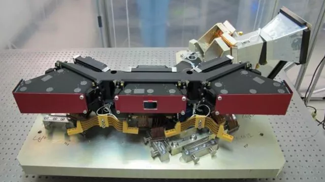
From April 1998 to May 2014, the VEGETATION instrument on the SPOT-4 and SPOT-5 satellites provided global daily monitoring of vegetation cover. Its successor subsequently flew on the European PROBA-V satellite.
Key information
| Mission | Monitor vegetation cover at regional and global scales using an imaging system operating in four spectral bands |
|---|---|
| Domain | Earth observation |
| Launch date | First launched 23 March 1998 |
| Partners | Belgium, Italy, Sweden, European Commission, ESA |
| Where | Earth orbit aboard SPOT-4, SPOT-5 and PROBA-V satellites |
| Lifetime | SPOT-4 (1998-2013) SPOT-5 (2002-2015) PROBA-V (2013-2021) |
| Status | Completed |
Key figures
- 3 satellites flew the instrument
- 4 independent cameras in instrument
- 1.15-to-1.7-km spatial resolution on first two instruments
- 100-to-300-m spatial resolution on third instrument
Key milestones
- 7 May 2013: VEGETATION-3 launched on PROBA-V satellite by Vega
- 3 May 2002: VEGETATION-2 launched on SPOT-5 satellite by Ariane 4
- 23 March 1998:VEGETATION-1 launched on SPOT-4 satellite by Ariane 4
- 1993: Decision to build VEGETATION-2 instrument
- 1992: Decision to build VEGETATION-1 instrument
- 1986: Studies get underway to build VEGETATION-1 instrument
Project in brief
Trees, plants and crops grow in step with the seasons and climate variations. CNES’s VEGETATION instrument kept close watch over their growth cycles for more than 16 years aboard the SPOT-4 and SPOT-5 satellites, bringing deeper insights into the dynamics of land cover and the impact of global warming.
It accomplished this feat with four independent cameras, each operating in a specific spectral band: blue (0.43-0.47 microns), red (0.61-0.68 microns), near-infrared (0.78-0.89 microns) and shortwave infrared (1.58-1.75 microns). The red and near-infrared bands are especially well suited to detecting the spectral signature of chlorophyll, whereas soil moisture and vegetation show up clearly in the shortwave infrared which, when combined with the blue band, affords good characterization and correction of atmospheric effects on reflectance. The VEGETATION instrument offered a ground swath of 2,200 kilometres and a spatial resolution of 1.15 to 1.7 kilometres.
A lighter version of VEGETATION was launched aboard the European PROBA-V satellite in 2013. With its 1-kilometre, 300-metre and 100-metre resolutions, this instrument was both a follow-on to VEGETATION and a precursor of the SLSTR instrument (Sea and Land Surface Temperature Radiometer) on the Sentinel-3 satellites. The VEGETATION programme was developed by France, Belgium, Italy and Sweden with the backing of the European Commission.
CNES’s role
The VEGETATION tasking centre (CPV) was operated by CNES. It was a component of the SPOT control centre (CMP), preparing and uploading imaging work plans to the VEGETATION instruments. The CMP also kept a check on the instruments’ health and reconfigured them where necessary.
The VEGETATION image quality centre (QIV) was also operated by CNES. The QIV provided regular monitoring of the radiometric and geometric performance of the VEGETATION instruments, calibrated them and sent new coefficients on a monthly basis to the VEGETATION image processing centre (CTIV).
Contacts
Continental Biosphere subject matter expert
Philippe Maisongrande
E-mail: philippe.maisongrande at cnes.fr


