EGNOS (European Geostationary Navigation Overlay Service) augments the accuracy and reliability of GPS signals and provides an integrity message crucial for safety-of-life applications. It was designed to meet the needs of civil aviation, in particular to guide aircraft during approach phases.
Key information
| Mission | Corrects GPS positioning signals and certifies their integrity |
|---|---|
| Domain | Telecoms, navigation |
| Entered service | 2009 |
| Partners | European Union, European Commission, EUSPA, ESA, ESSP |
| Where | Geostationary orbit (35,786 km) |
| Lifetime | Guaranteed through to 2040 |
| Status | In operation |
Key figures
- 44 ground stations
- 2-m geolocation accuracy
- 2 mission control centres
- 3 geostationary satellites
Key milestones
- 1 January 2021: GSA becomes the EU Agency for the Space Programme (EUSPA)
- 1 January 2014: European GNSS Agency (GSA) tasked with operating EGNOS
- March 2011: EGNOS safety-of-life service for civil aviation certified and operational
- October 2009: EGNOS Open Service operational
- 1995: Development of EGNOS programme begins
Project in brief
EGNOS (European Geostationary Navigation Overlay Service) augments the accuracy and reliability of GPS signals and provides an integrity message crucial for safety-of-life applications. It was designed to meet the needs of civil aviation, in particular to guide aircraft during approach phases.
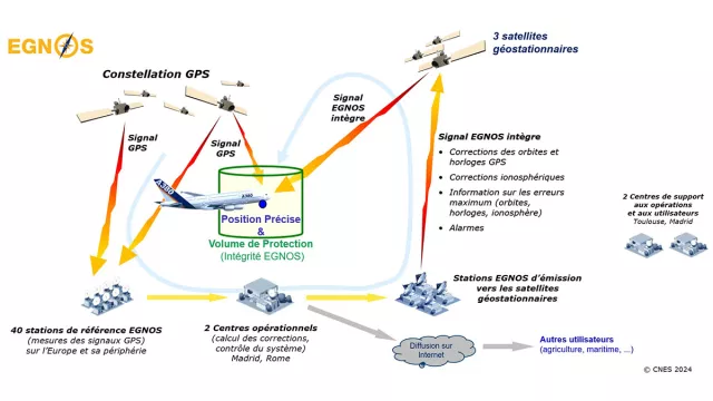
Developed between 1995 and 2009, EGNOS was certified for civil aviation in 2011. The EGNOS system measures signals from the GPS constellation via a network of 40 European stations and compares them with the stations’ position to deduce positional and integrity errors in the GPS signals. This information is fed into a centralized system to provide ‘certified’ information encoded in standardized messages. EGNOS payloads on geostationary satellites then relay these messages to users.
While EGNOS thus augments positioning accuracy, above all it provides integrity information in real time in the form of a protection level that gives users the maximum possible error regarding their position. This service was designed chiefly for air navigation, but it also serves other critical applications like rail. It is also aiding agriculture and robotics, for example. The system relies on an infrastructure of 40 Ranging and Integrity Monitoring Stations (RIMS) on the ground that receive and measure GPS signals, six Navigation Land Earth Stations (NLES) that uplink messages to the geostationary satellites and two control centres handling EGNOS communications and operations. The service is provided by certified operator ESSP (European Satellite Service Provider), whose headquarters and technical teams are in Toulouse and its service centre in Madrid.
EGNOS offers three services:
- Open Service (OS) improves positioning accuracy by correcting error sources affecting the GPS signals and is designed for a broad spectrum of applications.
- Safety of Life (SoL) service exploits the full power of EGNOS to deliver an integrity message. Certified by European civil aviation authorities, the SoL service is used by airports for procedures on the ground and in flight, notably for precise aircraft guidance during approach.
- EDAS (EGNOS Data Access Service) provides on-line access to raw reference station data and corrections from satellites in real time.
EGNOS is today a vital tool for the air transport sector, notably to assure compliance with the PBN regulation (Performance Based Navigation) for civil aviation operators.
Long-term upgrades to this European service are planned, notably for 2028 to augment signals from the Galileo and GPS constellations on two frequencies. This upgrade will afford better accuracy and service continuity, wider coverage and further improved reliability.
CNES’s role
CNES initiated the EGNOS concept and hosts project teams from the EU Agency for the Space Programme (EUSPA) and the European Space Agency (ESA), and provides independent assessment of the system’s performance.
Contacts
Head of Navigation Programme
Jean Marechal
E-mail: jean.marechal at cnes.fr
Head of Telecoms & Navigation
Jean-Philippe Taisant
E-mail: jean-philippe.taisant at cnes.fr
GEMOP (Galileo & Egnos Monitoring of Performance, EUSPA) grant Project Leader
Julien Colasson
E-mail: julien.colasson at cnes.fr


